Burning Man Photo-Essay
|
|
 |
|
|
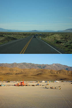 |
ENVIRONMENT: . . . . . . . . . • Topography •
These two images highlight the travel toward Black Rock Desert and the fossil lakebed itself, circumscribed by a rocky boundary.
The road curves to the right around Pyramid Lake and a Native American reservation. You can imagine that if this lake were drained and dried, it would mirror the Playa further north, ringed by mountains, a flat, dry 'beach'.
You can see in the lower photo a red structure - that is a temple. The thin ring of settlement is the tent city.
|
|
|
|
"Topography montage" |
 Slide #3 / 70 Slide #3 / 70  |
|